 A section of Little Shamokin Creek outside of Sunbury that is popular for stocking and fishing is much lower in water volume than normal for this time of year. Lower stream flow causes the stream to warm up faster and make it easier for predators to see them After stocking trout on the Little Shamokin Creek recently, Jacob Bennett, of the Pennsylvania Fish and Boat Commission, acknowledged that local waterways are definitely running below levels expected for mid-April. "Yeah, they are low, which will likely mean very warm and shallow creeks," he said. "That is not great for stocked fish or places like Penns (Creek) with natural reproduction." Statistically, every monitoring station the United States Geological Survey (USGS) operates in the region is currently below the 25th percentile and several are below the 10th percentile for this time of year, according to Matt Wilson, director of the Susquehanna University's Freshwater Research Institute. "The best available data for the Susquehanna watershed -- and the majority of the country -- comes from US Geological Survey stream gauge stations," he said "Most of these stations continuously monitor discharge (total volume) of water, stage height (the depth of the stream or river relative to a constant point), or both. Most of these have been operating for several decades, so they provide a wealth of information about how flows have changed over time." Below is the USGS map of real-time steam flow compared to historical stream flow for the date of April 19. 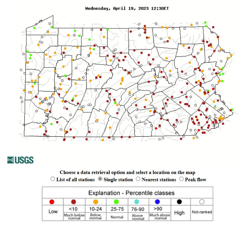 "The Susquehanna River Basin has experienced below normal precipitation over the last 30, 60, and 90 days," said John Balay, the planning and operations manager for the Susquehanna River Basin Commission (SRBC). Wilson agreed, pointing to lack of precipitation over the winter months as a major contributing factor. "A warm winter translates to no or little snowpack that would slowly melt in the spring and increase flow. We are also starting to see more intense and less frequent rainfall events which leads to less infiltration of rainfall into the groundwater, which then has less ability to support in-stream flow during drought periods," he said. "As periods like this increase in the future, it makes our streams more susceptible to higher high flows during storms and lower low flows between those storms." Both immediate and long-term impacts of such a low water table for this time of year can be hard to predict, according to Wilson, but coud be signifcant because many species have evolved life cycles synched to predictable seasonal events like warming temperatures or increasing daylight in the spring. "Low water levels can cause water temperatures to increase more rapidly in the spring, changing or confusing the timing of these natural cues so that aquatic insects emerge earlier, or fish may migrate upstream to spawn earlier. Low water coupled with warm temperatures can be particularly troublesome for native migrating species, like shad or suckers, because fish might become trapped partway to their spawning grounds with temperatures rising while they wait for higher flows to swim upstream," he said. "Amphibians are also at risk as drought periods in the spring can cause entire vernal pools to dry up, just as you salamanders and frogs are developing and most vulnerable." As far as curbing potential long-term impacts of this sort of weather pattern, one solution Wilson suggests is encouraging local beaver populations. "Beaver ponds are great for increasing wetlands and groundwater infiltration so that our streams might 'capture' more of the water during major storm events to release slowly during droughts, rather than watching it all wash downstream to the Bay," he said. "Not to mention all of that groundwater storage acts like a root cellar -- releasing cold water into the stream during summer months when warmer temperatures and lower flows are likely to be stressful." The SRBC, which handles permitting in relation to water consumption across our watershed, is especially monitoring current stream flow patterns. "Many commission-regulated water withdrawals are subject to passby flow requirements during low flow periods to avoid impacts," said Balay, suggesting that from a long-term outlook: "Water users may need to call for water use reductions and/or rely on backup water supply sources." Beyond potential environmental and water-use impacts, such a low water level in mid-April could have quite a big impact on recreational opportunities as well heading into the summer months when water levels typically drop. "We have a bunch of big activities planned from a kayaking and boating standpoint this summer, and it is especially concerning to head into the typical boating season already so far behind in precipitation and water flow," said Riverkeeper John Zaktansky. "We are hoping that the region starts to see an increase in steady, soaking precipitation events or it may be really hard to kayak or run a boat down certain stretched of streams and the river itself later this summer." According to the National Weather Service, the watershed is 51-75 percent below average in precipitation over the last month and between 26-50 percent below for the past 90-day and year-long periods, according to this map. The level of departure in precipitation over the past 30 days can be viewed, as well, in the map below: 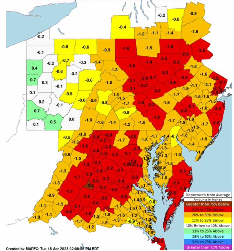 What will it take to reverse the waterflow concerns for the coming seasons?
"This is a great question that feels like it should be easy to answer, but it depends what kind of timescale we are talking about, local land use, and how much of a stream or river's flow comes from springs/groundwater," said Wilson. "It also depends on how that rainfall arrives, whether it is as April showers or torrential downpours." Rainfall predictions for the coming week and beyond can be monitored via the National Weather Service at this link.
1 Comment
7/7/2023 07:58:42 am
I agree with this and everyone should read this blog for them to know. Leave a Reply. |
AuthorsRiverkeeper John Zaktansky is an award-winning journalist and avid promoter of the outdoors who loves camping, kayaking, fishing and hunting with the family. Archives
July 2024
Topics |
 RSS Feed